Drones, also known as unmanned aerial vehicles (UAVs), have transformed the way aerial photography and mapping are conducted. What was once an expensive and time-consuming task requiring helicopters, airplanes, or satellites is now accessible and cost-effective through drone technology. Today, drones are widely used across industries such as construction, agriculture, filmmaking, surveying, and disaster management. Their ability to capture high-resolution images and create accurate maps has redefined how we view and analyze the world from above.
Revolutionizing Aerial Photography
One of the most significant roles of drones lies in aerial photography. With advanced cameras, stabilization systems, and intelligent flight modes, drones provide perspectives that were once limited to professional equipment.
- Drones capture breathtaking landscapes, real estate properties, and event coverage from unique angles.
- High-definition and 4K cameras allow for detailed and cinematic shots.
- Built-in stabilization ensures steady footage, even in windy conditions.
This accessibility has opened doors for photographers, filmmakers, and content creators to produce professional-quality visuals without the cost of renting aircraft.
Advancements in Mapping and Surveying
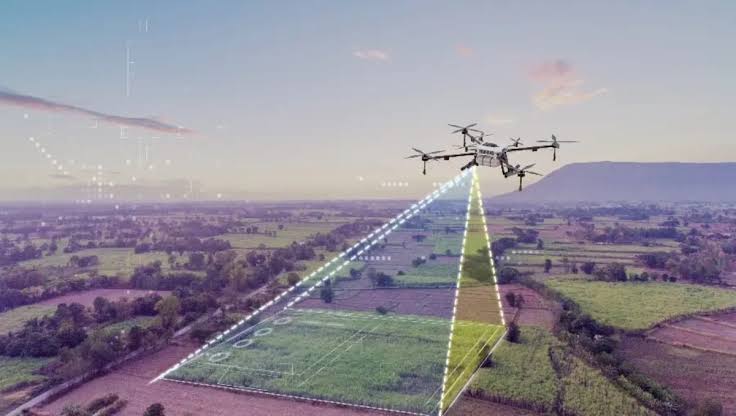
Mapping and surveying have seen significant improvements with the adoption of drone technology. Equipped with GPS and advanced sensors, drones can capture detailed topographical data quickly and accurately.
- Drones create 2D orthomosaic maps by stitching together multiple high-resolution images.
- 3D models and terrain mapping help in planning construction, mining, and urban development projects.
- Accuracy in centimeter-level detail makes them reliable tools for land measurement and inspection.
Compared to traditional methods, drone mapping is faster, safer, and more cost-effective, especially in difficult terrains.
Applications in Agriculture
Agriculture is one sector where drones have proven particularly valuable. Farmers use drone-based aerial mapping to monitor crops, assess soil conditions, and optimize land use.
- Multispectral cameras help detect crop stress and plant health issues.
- Drones identify areas requiring irrigation, fertilizer, or pest control.
- Yield predictions and farm planning improve overall productivity.
This precision agriculture approach ensures resources are used efficiently, leading to better harvests and reduced costs.
Role in Infrastructure and Construction
Construction companies rely on drones for site monitoring, progress tracking, and structural inspections. By capturing aerial imagery and generating detailed maps, drones help project managers keep track of developments.
- 3D models assist in architectural planning and design validation.
- Progress monitoring reduces project delays and improves reporting.
- Drones enhance worker safety by minimizing the need for manual inspections in dangerous areas.
This integration of drones into construction workflows streamlines operations and boosts efficiency.
Environmental and Disaster Management
Drones play a crucial role in environmental conservation and disaster response. Their ability to access remote or hazardous areas makes them indispensable tools in critical situations.
- During floods, earthquakes, or wildfires, drones provide real-time aerial imagery for rescue operations.
- Environmental agencies use drones for monitoring deforestation, wildlife tracking, and habitat preservation.
- Climate researchers benefit from drones for collecting atmospheric and geographical data.
These capabilities make drones powerful tools for protecting both people and nature.
Advantages of Drones in Aerial Work
The popularity of drones in photography and mapping comes from several key advantages:
- Cost efficiency compared to traditional aircraft.
- Faster data collection and processing.
- High-resolution imagery and precise mapping.
- Ability to access hard-to-reach or dangerous areas.
- Versatility across multiple industries.
These benefits explain why drones have become indispensable for both professionals and hobbyists.
Challenges and Limitations
Despite their benefits, drones face challenges that limit their use in some areas.
- Strict regulations and licensing requirements in many countries.
- Limited flight time due to battery constraints.
- Weather sensitivity affecting performance.
- Concerns over privacy and data security.
Addressing these challenges requires technological advancements and regulatory adjustments that balance innovation with safety.
Future of Drones in Photography and Mapping
As drone technology advances, the future promises even greater capabilities. Artificial intelligence, machine learning, and improved sensors will enhance drone applications.
- Autonomous flight modes will allow drones to conduct complex mapping missions without human intervention.
- Integration with cloud platforms will enable real-time data sharing and analysis.
- Lightweight batteries and solar-powered drones may extend flight times significantly.
These innovations will continue to push the boundaries of aerial photography and mapping, making drones even more powerful tools across industries.
Conclusion
The role of drones in aerial photography and mapping has transformed how professionals capture, analyze, and use visual data. From creative filmmaking to precise land surveying, drones have opened up endless possibilities. Their impact extends to agriculture, construction, disaster response, and environmental conservation, proving their versatility. While challenges exist, the rapid pace of innovation ensures that drones will remain at the forefront of aerial technology, shaping how we view and understand our world.