The Role of Drones in Aerial Photography and Mapping
Drones have become indispensable tools in the fields of aerial photography and mapping. What once required helicopters, expensive equipment, and specialized crews can now be accomplished with compact unmanned aerial vehicles (UAVs). As of 2025, drone technology has advanced far beyond its early capabilities, offering high-resolution imagery, autonomous flight paths, and data processing power that is transforming industries ranging from agriculture and real estate to construction, urban planning, and environmental monitoring.
This shift has enabled professionals and even hobbyists to capture data with precision, speed, and safety, opening up new possibilities for visual documentation, geographical mapping, and land analysis.
Advantages of Drone-Based Aerial Photography
The primary benefit of drones in aerial photography lies in their versatility. With minimal setup and operating costs, drones can reach angles and elevations that were previously inaccessible or prohibitively expensive.
Key advantages include:
- Low-altitude imagery: Drones can fly at lower altitudes than planes or satellites, allowing for sharper and more detailed images.
- Real-time monitoring: Operators can view live feeds from the drone’s camera, adjusting angles and capturing footage in real time.
- Cost-effective operations: Compared to hiring helicopters or renting cranes, drones are significantly more affordable.
- Rapid deployment: Drones can be launched in minutes, making them ideal for fast-paced environments like event coverage or disaster zones.
- Enhanced creative flexibility: Cinematic shots such as fly-throughs, panoramic views, and low-hover tracking are now widely accessible to videographers and content creators.
These strengths have made drones a standard tool in media production, wedding photography, sports coverage, and travel vlogging.
Precision and Accuracy in Mapping
Mapping with drones is not just about taking pictures from the sky. It’s about collecting georeferenced data that can be used for land surveying, infrastructure planning, resource management, and geographic information system (GIS) applications.
Drones equipped with GPS, LiDAR, and high-resolution sensors can create:
- Orthomosaic maps: Detailed and geometrically corrected aerial images stitched together from multiple drone shots.
- 3D terrain models: Topographical representations that reflect real-world elevation and landform changes.
- Point clouds: Dense collections of data points that represent the surface of objects or terrain for advanced analysis.
- Thermal maps: Useful for assessing energy efficiency, detecting water leaks, or monitoring plant health.
With centimeter-level accuracy, these tools allow engineers, urban developers, and environmental scientists to make informed decisions quickly and safely.
Industries Transforming Through Drone Mapping
The impact of drone mapping extends across multiple sectors. In 2025, the following industries are increasingly reliant on UAVs for spatial data:
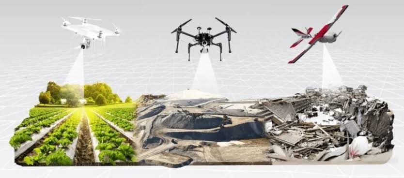
- Agriculture: Farmers use drones for crop monitoring, soil health analysis, and irrigation planning, improving yield while reducing resource waste.
- Construction and real estate: Drones are used for land surveys, site planning, progress documentation, and marketing visuals for property listings.
- Mining and quarrying: UAVs offer safer and more efficient ways to map excavation zones, measure stockpile volumes, and monitor site changes over time.
- Disaster response: After natural disasters, drones help first responders assess damage, locate survivors, and plan recovery efforts.
- Environmental conservation: Drones monitor deforestation, track wildlife, map ecosystems, and assess changes in protected areas with minimal human interference.
In each case, drones not only improve efficiency but also reduce risk and enhance the quality of data collected.
Technological Advancements Enhancing Drone Use
Drone technology has rapidly evolved to meet the growing demands of aerial photography and mapping. Modern UAVs in 2025 now feature:
- Autonomous flight planning: Users can program drones to follow specific flight paths and cover defined areas without manual intervention.
- Obstacle avoidance: Using AI and sensors, drones can navigate complex environments and avoid collisions in real-time.
- RTK and PPK GPS systems: These systems enable precise geolocation of images with minimal error, critical for survey-grade mapping.
- Cloud-based data processing: Images and data can be uploaded and processed on cloud platforms, generating maps and models within hours.
These innovations allow users to conduct large-scale mapping projects with fewer errors and faster turnaround times than ever before.
Regulatory and Ethical Considerations
Despite the benefits, drone operations raise important concerns related to airspace safety, privacy, and ethical use. In 2025, most countries have established comprehensive drone regulations, requiring operators to obtain certifications, register devices, and follow strict flight protocols.
Common regulatory standards include:
- No-fly zones: Drones are restricted near airports, government buildings, and military zones.
- Altitude limits: Drones are typically limited to a maximum height of 120 meters (400 feet) above ground.
- Line-of-sight operation: Most jurisdictions require that drones remain within the operator’s visual line of sight.
- Data privacy laws: Recording individuals or private property without consent can result in legal penalties.
Operators must also consider ethical implications, particularly when capturing sensitive locations or data. Ensuring transparency and responsible usage is key to maintaining public trust in drone technologies.
Accessibility and the Rise of Hobbyist Mapping
Drone mapping is no longer limited to large firms or government projects. With affordable consumer-grade drones and user-friendly software, hobbyists and small businesses are entering the space. Platforms like DroneDeploy, Pix4D, and DJI Terra allow users to map areas with minimal training.
This democratization of drone technology has led to:
- Community-driven mapping projects: Local groups now create open-source maps of parks, trails, or urban neighborhoods.
- Citizen science initiatives: Volunteers use drones to support environmental studies, biodiversity counts, and archaeological surveys.
- Entrepreneurial opportunities: Freelancers offer mapping services to farmers, real estate agents, or municipalities.
As more people gain access to drone tools, innovation in how we see and understand the world is accelerating at an unprecedented pace.
Future Prospects for Drones in Mapping and Imaging
Looking ahead, the role of drones in aerial photography and mapping will only grow. Upcoming advancements may include:
- Integration with AI for real-time image analysis
- Swarm drone operations for large area coverage
- Improved flight endurance with solar or hydrogen fuel
- Blockchain-secured data for verifiable mapping
These developments will further reduce barriers, enhance data integrity, and allow deeper integration with other emerging technologies such as augmented reality and digital twins.
In the years to come, drones will not just capture our world from above—they will help us manage, design, protect, and understand it more comprehensively than ever before.