Natural disasters are happening more often and with greater strength because of climate change, city growth, and more people worldwide. From wildfires and hurricanes to floods and earthquakes, we need better ways to respond and recover.
By July 2025, technology is greatly improving how governments, aid groups, and communities get ready for, react to, and recover from disasters. New tools for real-time communication, data analysis, automation, and digital teamwork are helping deliver aid faster, assess damage quickly, and rebuild more effectively. These advances are saving lives and making recovery efforts fairer, faster, and stronger.
Early Warning Systems and Real-Time Monitoring
One of the most critical aspects of disaster management is the ability to anticipate and respond to threats before they escalate. Technology has significantly advanced early warning systems by using satellite data, radar, artificial intelligence, and remote sensors to monitor environmental conditions in real time.
In 2025, smart sensors placed in oceans, forests, and fault lines provide immediate updates on changes in water temperature, seismic activity, or atmospheric pressure. These sensors feed data into AI models that can predict disasters like tsunamis, landslides, or cyclones with impressive accuracy. Warnings are then sent through mobile networks and social media platforms to populations at risk, giving them crucial minutes or hours to evacuate or prepare.
Mobile applications developed by national meteorological services now integrate real-time alerts with GPS data, allowing citizens to receive hyper-localized notifications on impending dangers. These advancements have proven instrumental in saving lives and reducing the burden on emergency services during crises.
Drones and Robotics in Emergency Response
The use of drones and robotics in disaster zones is revolutionizing how search and rescue missions are conducted. After earthquakes, floods, or building collapses, drones equipped with high-resolution cameras and thermal imaging can access dangerous or inaccessible areas quickly and safely.
As of mid-2025, humanitarian organizations are deploying autonomous drones to deliver medical supplies, food, and clean water to remote regions within hours of a disaster. These drones bypass damaged roads and infrastructure, ensuring aid reaches those in need without delay.
Robotic dogs and snake-like machines are also being used to search through rubble for survivors. These tools are fitted with audio sensors, cameras, and communication devices that allow first responders to locate trapped individuals without putting human rescuers at risk. In some cases, robots are equipped with 3D mapping systems to survey and reconstruct collapsed structures for safer operations.
Geographic Information Systems (GIS) and Data Mapping
Technology has also enabled real-time mapping of disaster zones through Geographic Information Systems (GIS). These systems analyze vast amounts of data—including satellite images, population density, and weather models—to provide detailed, interactive maps that guide decision-making.
In 2025, GIS platforms are increasingly being used to prioritize evacuation zones, assess infrastructure damage, and plan logistics for relief delivery. Local governments and international aid agencies collaborate on cloud-based GIS dashboards that display real-time updates on road accessibility, shelter availability, and power outages.
Crowdsourced data, collected via smartphones and social media, also feeds into these maps to offer a granular view of conditions on the ground. This participatory approach ensures that aid reaches not only the obvious urban centers but also smaller, less-connected communities that might otherwise be overlooked.
Communication Tools and Mobile Coordination
Communication during and after a disaster is critical. Traditional channels often fail when infrastructure is damaged, so technology is filling the gaps with innovative solutions. Mesh networks, for instance, allow smartphones and other devices to communicate without relying on cellular towers or Wi-Fi, creating a local internet in areas cut off from the grid.
In July 2025, emergency response teams increasingly rely on encrypted communication platforms that ensure privacy and coordination among multiple stakeholders. These platforms integrate GPS, chat, real-time video, and cloud storage, enabling seamless collaboration across borders and organizations.
Moreover, mobile apps now provide citizens with direct access to emergency services, allowing them to report their locations, send pictures of damage, or request specific types of assistance. This two-way communication loop improves response accuracy and builds public trust in relief efforts.
AI and Machine Learning for Damage Assessment
Artificial intelligence is now playing a central role in post-disaster analysis. After a hurricane or wildfire, assessing the scope of damage can take days or even weeks using manual methods. AI-powered image recognition systems can process satellite and drone images to identify destroyed buildings, flooded areas, and disrupted infrastructure within minutes.
In 2025, insurance companies and government agencies use these tools to fast-track damage claims, allocate resources, and plan long-term recovery strategies. Predictive models also help estimate the economic impact of a disaster and prioritize which regions need immediate rebuilding.
Machine learning algorithms continuously improve by learning from each new event, making future assessments more accurate and rapid. These technologies are especially useful in large-scale disasters where human inspection would be too time-consuming or dangerous.
Blockchain for Transparent Aid Distribution
One of the persistent challenges in disaster relief is ensuring that aid reaches the intended recipients. Blockchain technology offers a decentralized, tamper-proof way to track donations, supplies, and resources. In 2025, some humanitarian organizations have adopted blockchain systems to provide transparent, auditable trails of financial transactions and material distribution.
This ensures that donors can see exactly how their contributions are used, and affected communities can receive funds directly through digital wallets or QR-coded identification cards. Blockchain-based platforms also reduce fraud, prevent duplication of aid, and improve accountability in high-pressure scenarios.
These systems are particularly beneficial in refugee camps and temporary shelters, where traditional banking infrastructure may not exist. By digitizing aid flows, blockchain helps build trust among stakeholders and enhances the effectiveness of disaster recovery efforts.
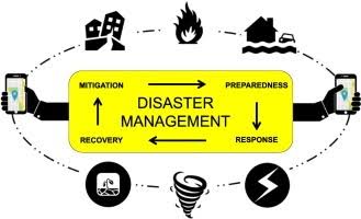
Conclusion: A Technological Blueprint for Resilience
Technology is redefining how the world prepares for, responds to, and recovers from disasters. From early warnings and rescue operations to resource distribution and damage assessment, digital tools are making each phase of disaster management more efficient, inclusive, and responsive.
While no technology can prevent natural disasters, the innovations available as of July 2025 offer hope for minimizing their impact. However, to realize the full potential of these technologies, investment in digital infrastructure, cross-sector collaboration, and community training is essential.
The future of disaster response lies in the fusion of human expertise and intelligent technology. By embracing this synergy, societies can become more resilient, saving more lives and rebuilding faster in the wake of every crisis.